Helmond uses satellite measurements to gain monthly insight into air quality
Municipalities that want a clear picture of local air quality often run into the limitations of the national monitoring network. For Helmond, the nearest representative monitoring stations for substances such as NO₂ and particulate matter are in Eindhoven or Vredepeel. Ultimately, these stations are too far from Helmond itself to provide meaningful local insights. Since 2023, the municipality has been addressing this gap with an additional data source: monthly satellite measurements of air quality, combined with ground-based measurements and a purpose-built AI model.
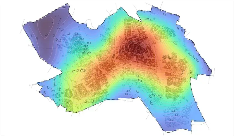
Origin and application of the data
The satellite measurements did not come through a procurement process, but as a donation. Former mayor Fons Jacobs won the data at a conference and transferred it to the municipality. With a contribution from the Clean Air Agreement, the initiative was given a more permanent footing in 2023. Since then, Helmond has used the imagery to identify where concentrations of particulate matter and nitrogen dioxide are higher or lower across the city, and how they spread.
Added value compared with existing measurement methods
The main difference compared with the RIVM's GCN concentration maps lies in how up to date and local the data is. Those maps show annual averages, whereas the satellite data is updated monthly. This makes seasonal peaks in concentrations visible, even when the annual average remains within the applicable limits.
The satellite imagery does not replace existing measurement methods; it is used alongside them. Helmond compares its own data with measurements from the National Air Quality Monitoring Network and combines it with local initiatives such as Helmond Meetnet and the Innovative Monitoring Network of the Southeast Brabant Region.
Next steps
In the coming years, Helmond will investigate whether satellite data can be combined with other data sources to distinguish general background pollution from pollution originating specifically within the city. Traffic has already been identified as an important factor. The municipality also wants to determine whether neighbourhoods with greater health inequalities are consistently exposed to poorer air quality, allowing future measures to be targeted more effectively.
The role of satellite data at Caeli
At Caeli, we recognise a broader trend in Helmond's approach: municipalities need local, factual data that complements the limited coverage of the national monitoring network. Our Air Quality Monitor was developed to meet this need. Satellite observations are combined with advanced algorithms to produce air quality data with high spatial resolution, which can be directly assessed against WHO and EU guidelines. This enables municipalities, like Helmond, to make informed decisions about where measures are needed most.
Scientific validation with a high degree of reliability
Because policy decisions of this kind require reliable figures, we have had our underlying model, Argus-AQM, extensively validated by external parties. The model's nitrogen dioxide (NO₂) estimates were compared against more than 240,000 measurements from 3,616 official monitoring stations across Europe, covering the period from 2019 to early 2026. To prevent the model from effectively giving itself an advantage, entire regions were excluded from the training data during validation. This meant the model had to predict air quality in locations it had not encountered before. The full report is available from us, and we would be happy to discuss it with you.
The validation results show that the model achieves an R² of 0.85 for the Netherlands, along with the lowest margin of error of all the European countries examined (3.07 µg/m³). These figures demonstrate that, when properly validated, satellite-based estimates can provide a reliable complement to physical monitoring stations. This is precisely the role the data now fulfils in Helmond.
Would you like to find out how satellite-based monitoring could provide insights for your municipality? Feel free to contact Martin Smit at martin@caeli.nl or +31 6 55772285.